|
تضامنًا مع حق الشعب الفلسطيني |
نهر كوتيناي
اذهب إلى التنقل
اذهب إلى البحث
| نهر كوتيناي | |
|---|---|
| الخصائص | |
| تعديل مصدري - تعديل |
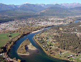
كوتيناي[5] والذي عرف تاريخيا باسم فلاتبو)[7] هو نهر كبير في جنوبي شرقي كولومبيا البريطانية, بكندا، وشمالي مونتانا وإداهو في الولايات المتحدة الأمريكية. وهو أحد أعلى الروافد الكبرى لنهر كولومبيا, والذي يعد أكبر نهر في شمال أمريكا والذي يصب في المحيط الهادئ.
أعمال مستشهد بها
- Basque، Garnet، المحرر (1993). Frontier Days in British Columbia. Heritage Group Distribution. ISBN:1-894384-01-6. اطلع عليه بتاريخ 2010-04-12.
- Brink، Nicky L,؛ Bown، Stephen R. (2007). Forgotten highways: wilderness journeys down the historic trails of the Canadian Rockies. Brindle & Glass. ص. 131–134. ISBN:1-897142-24-2.
{{استشهاد بكتاب}}: صيانة الاستشهاد: أسماء متعددة: قائمة المؤلفين (link) صيانة الاستشهاد: علامات ترقيم زائدة (link) - Burpee، Lawrence Johnstone (1908). The search for the western sea: the story of the exploration of north-western America. Musson Book Company Ltd. اطلع عليه بتاريخ 2010-04-22.
- Hayes، Derek (2006). Historical Atlas of Canada. Douglas & McIntyre. ص. 207–208. ISBN:1-55365-077-8.
- Holbrook، Stewart (1990) [1956]. The Columbia: The Classic Portrait of the Great River of the Northwest. Comstock Editions. ISBN:0-89174-051-1.
- Jenish، D'Arcy (2004). Epic wanderer: David Thompson and the mapping of the Canadian West. University of Nebraska Press. ISBN:0-8032-2600-4.
- Landers، Rich؛ Hansen، Dan؛ Huser، Verne؛ North، Doug (2008). Paddling Washington: Flatwater and Whitewater Routes in Washington State and the Inland Northwest. Mountaineers Books. ISBN:1-59485-056-9.
- Miller، Naomi (2002). Fort Steele: gold rush to boom town. Heritage Group Distribution. ISBN:1-894384-38-5.
- Palliser، John؛ Blakiston، Thomas Wright (1860). Exploration—British North America: Further papers relative to the exploration by the expedition under Captain Palliser of that portion of British North America which lies between the northern branch of the river Saskatchewan and the frontier of the United States, and between the Red River and …. اطلع عليه بتاريخ 2010-04-22.
{{استشهاد بكتاب}}:|عمل=تُجوهل (مساعدة) - "Introduction" (PDF). Kootenai Subbasin Plan. Northwest Power and Conservation Council. 31 أكتوبر 2005. مؤرشف من الأصل (PDF) في 2013-05-08. اطلع عليه بتاريخ 2010-03-25.
- "Characterization of Biomes" (PDF). Kootenai Subbasin Plan. Northwest Power and Conservation Council. 31 أكتوبر 2005. مؤرشف من الأصل (PDF) في 2012-02-13. اطلع عليه بتاريخ 2010-03-28.
- "Fish and Wildlife Communities" (PDF). Kootenai Subbasin Plan. Northwest Power and Conservation Council. 31 أكتوبر 2005. مؤرشف من الأصل (PDF) في 2012-02-13. اطلع عليه بتاريخ 2010-04-17.
قراءة إضافية
| في كومنز صور وملفات عن: نهر كوتيناي |
- Sullivan، Gordon (2008). Saving Homewaters: The Story of Montana's Streams and Rivers. Woodstock, VT: The Countryman Press. ISBN:978-0-88150-679-2.
مراجع
- ^ Kootenai Subbasin Plan Introduction, p. 11
- ^ أ ب "Kootenay Lake Outflow Near Corra Linn – Monthly Mean Discharge". HYDAT Archived Hydrometric Data. Environment Canada. 1937–2010. مؤرشف من الأصل في 2012-04-21. اطلع عليه بتاريخ 2011-11-25.
- ^ أ ب "Kootenai River Basin - Hydrology". International Alliance for Water Quality and Aquatic Resources. Kootenai River Network, Inc. 14 مارس 2010. مؤرشف من الأصل في 2007-09-06. اطلع عليه بتاريخ 2010-03-25.
- ^ أ ب Source elevations and coordinates derived from Google Earth using data from Canadian topo maps
- ^ أ ب U.S. Geological Survey Geographic Names Information System: Kootenai River
- ^ أ ب "The Rivers - Stories". Balance of Power. 2007. مؤرشف من الأصل في 2011-11-06. اطلع عليه بتاريخ 2008-09-03.
- ^ Palliser، John (1863). Exploration - British North America - the journals, detailed reports, and observations relative to the exploration, by Captain Palliser, of that portion of British North America, which, in latitude, lies between the British boundary line and the height of land or watershed of the northern or ... G.E. Eyre and W. Spottiswoode for H.M. Stationery Off. ص. 162.
{{استشهاد بكتاب}}: الوسيط|تاريخ الوصولبحاجة لـ|مسار=(مساعدة)
