ملف:Wostok-Station core32.jpg

من أرابيكا، الموسوعة الحرة
اذهب إلى التنقل اذهب إلى البحث

الملف الأصلي(1٬000 × 644 بكسل حجم الملف: 89 كيلوبايت، نوع MIME: image/jpeg)

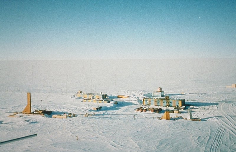
الوصف Wostok-Station (NOAA), photo by Todd Sowers, Lamont-Doherty Earth Observatory (LDEO), Columbia University, Palisades, New York, for NOAA. The Vostok site was chosen by the Soviet Union for the deep coring possibilities it offered. French and, later, American scientists became interested in the Soviet research and began to participate in coring activities at the site. This panoramic photo of Vostok Station shows the layout of the camp. The striped building on the left is the power station while the striped building on the right is where researchers sleep and take meals. The building in the background with the red- and white-striped ball on top is the meteorology building. Caves were dug into the ice sheet for storage, keeping cores at an ideal -55 degrees C year round.
التاريخ (date attribute of the source file)
المصدر http://www.ngdc.noaa.gov/paleo/slides/slideset/15/15_300_slide.html
المؤلف Todd Sowers, Lamont-Doherty Earth Observatory (LDEO), Columbia University, Palisades, New York for NOAA
الترخيص
(إعادة استخدام هذا الملف)
Public domain
تحتوي هذه الصُّورة مواداً أنتجت بواسطة الإدارة الوطنيَّة للمحيطات والغلاف الجوي في الولايات المتَّحدة الأمريكيَّة. أُنشئت هذه المواد مِن قبل مُوظَّفٍ خلال أدائه لواجباته الرَّسميَّة أي أنَّها عملٌ من أعمال الحكومة الاتحاديَّة للولايات المتَّحدة، ولذلك فهي في النِّطاق العامِّ.

العربية  čeština  Deutsch  Zazaki  English  español  eesti  suomi  français  hrvatski  magyar  italiano  日本語  한국어  македонски  മലയാളം  Plattdüütsch  Nederlands  polski  português  română  русский  sicilianu  slovenščina  Türkçe  Tiếng Việt  简体中文  繁體中文  +/−

موقع آلة التصوير٧٨° ٢٧′ ٥٢″ ج, ١٠٦° ٥٠′ ٥٠″ ق Kartographer map based on OpenStreetMap.هذه وغيرها من الصور في مواقعها على: خريطة الشارع المفتوحةinfo

سجلُّ الرَّفع الأصيل

(All user names refer to de.wikipedia)

  • 2004-07-02 17:33 Srbauer 768×494×8 (45575 bytes) Wostok-Station (NOAA)

taken from de.wikipedia; description page is/was here. Original uploader was Srbauer at de.wikipedia

الشروحات

أضف شرحاً من سطر واحد لما يُمثِّله هذا الملف
Panoramic view of the Russian Vostok Station, Antarctica, 2001.

العناصر المصورة في هذا الملف

يُصوِّر

١١ أكتوبر 2001

78°27'51.998"S, 106°50'49.999"E

تاريخ الملف

اضغط على زمن/تاريخ لرؤية الملف كما بدا في هذا الزمن.

زمن/تاريخصورة مصغرةالأبعادمستخدمتعليق
حالي00:21، 6 أبريل 2007تصغير للنسخة بتاريخ 00:21، 6 أبريل 20071٬000 × 644 (89 كيلوبايت)commonswiki>Raul6

ال1 ملف التالي مكررات لهذا الملف (المزيد من التفاصيل):

الصفحة التالية تستخدم هذا الملف:

بيانات وصفية