ملف:Stryi and Upper Dneistr Rivers.PNG

من أرابيكا، الموسوعة الحرة
اذهب إلى التنقل اذهب إلى البحث

الملف الأصلي(631 × 648 بكسل حجم الملف: 63 كيلوبايت، نوع MIME: image/png)

ملخص

الوصف
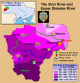
English: This is a map showing the Upper Dniestr River Basin, including its main tributary, the Stryi River, in the southwestern half of the Lviv Oblast in western Ukraine. It also shows the average annual precipitation by millimeters and inches for the region, and places the administrative centers of each of the raions in this area on the map. It includes and inset indicating where this is in relation to the rest of Ukraine, and provides the names of the closest villages to the Stryi River's head and mouth. I created this map, using Microsoft Paint, version 7.0, and borrowing data from Google Earth, and the 21st European Regional Conference 2005 - 15-19 May 2005 - Frankfurt (Oder) and Slubice - Germany and Poland report on "Floods Modeling in the Upper Dnister River Valley", by Ivan Kovalchuk, Andriy Mykhnovych, Volker Ehlert, Jörg Steidl, in conjunction with the Leibniz Centre for Agricultural Landscape Research (ZALF), Germany, and held at the Ivan Franko National University of L’viv, Ukraine, page4. URL: http://www.zalf.de/icid/ICID_ERC2005/HTML/ERC2005PDF/Topic_2/Kovalchuk.pdf
التاريخ ١٠ فبراير ٢٠١٠ (تاريخ الرفع الأصيل)
المصدر نُقِلت من en.wikipedia إلى كُومُنز بواسطة SreeBot.
المؤلف Saukkomies في ويكيبيديا الإنجليزية

ترخيص

Public domain وضع -Saukkomies في ويكيبيديا الإنجليزية-، وهو المؤلف، هذا العمل في النِّطاق العامِّ. يسري ذلك في كل أرجاء العالم.
في بعض البلدان، قد يكون هذا التَّرخيص غيرَ مُمكنٍ قانونيَّاً، في هذه الحالة:
يمنح Saukkomies الجميع حق استخدام هذا العمل
لأي غرض دون أي شرط ما لم يفرض القانون شروطًا إضافية.

سجلُّ الرَّفع الأصيل

صفحة الوصف الأصلية كانت هنا، تشير جميع أسماء المستخدمين التالية إلى en.wikipedia.

Upload date | User | Bytes | Dimensions | Comment

  • 2010-02-10 01:12 (UTC) | Saukkomies | 64995 (bytes) | 631×648 | I created this map, using Microsoft Paint, version 7.0, and borrowing data from Google Earth, and the 21st European Regional Conference 2005 - 15-19 May 2005 - Frankfurt (Oder) and Slubice - Germany and Poland report on "Floods Modeling in the Upper Dnist

الشروحات

أضف شرحاً من سطر واحد لما يُمثِّله هذا الملف

العناصر المصورة في هذا الملف

يُصوِّر

تاريخ الملف

اضغط على زمن/تاريخ لرؤية الملف كما بدا في هذا الزمن.

زمن/تاريخصورة مصغرةالأبعادمستخدمتعليق
حالي21:36، 18 سبتمبر 2011تصغير للنسخة بتاريخ 21:36، 18 سبتمبر 2011631 × 648 (63 كيلوبايت)commonswiki>SreeBot(Original text) : I created this map, using Microsoft Paint, version 7.0, and borrowing data from Google Earth, and the 21st European Regional Conference 2005 - 15-19 May 2005 - Frankfurt (Oder) and Slubice - Germany and Poland report on "Floods Modeling

ال1 ملف التالي مكررات لهذا الملف (المزيد من التفاصيل):

الصفحة التالية تستخدم هذا الملف: