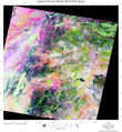
ملف:Landsate image of Zhawar Kili, in Khowst.png

من أرابيكا، الموسوعة الحرة
اذهب إلى التنقل اذهب إلى البحث

Landsate_image_of_Zhawar_Kili,_in_Khowst.png(348 × 378 بكسل حجم الملف: 234 كيلوبايت، نوع MIME: image/png)

ملخص

الوصف
English: Spectral ratio image of 30 meter resolution data from Landsat used to rapidly map the composition of the surface of Eastern Afghanistan and NW Pakistan. The colors were interpreted in terms of rock type based on field mapping in eastern Afghanistan and NW Pakistan. Three other NASA satellites were used to corroborate and extend this image. Possible terrorist camp locations were subsequently superimposed upon this image to narrow the number of possible targets based on geological clues in videotapes distributed by admitted terrorists. Data courtesy of USGS.
التاريخ تاريخ غير معروف
المصدر http://www.ohioview.org/research/ohioview_counterterror_factsheet4pdf.pdf
المؤلف USGS

ترخيص

Public domain

Bahasa Indonesia  català  čeština  Deutsch  eesti  English  español  français  galego  italiano  Nederlands  português  polski  sicilianu  suomi  Tiếng Việt  Türkçe  български  македонски  русский  മലയാളം  한국어  日本語  中文  中文(简体)  中文(繁體)  العربية  فارسی  +/−

الشروحات

أضف شرحاً من سطر واحد لما يُمثِّله هذا الملف

العناصر المصورة في هذا الملف

يُصوِّر

تاريخ الملف

اضغط على زمن/تاريخ لرؤية الملف كما بدا في هذا الزمن.

زمن/تاريخصورة مصغرةالأبعادمستخدمتعليق
حالي10:14، 15 نوفمبر 2008تصغير للنسخة بتاريخ 10:14، 15 نوفمبر 2008348 × 378 (234 كيلوبايت)commonswiki>Geo Swan{{Information |Description={{en|1=Spectral ratio image of 30 meter resolution data from Landsat used to rapidly map the composition of the surface of Eastern Afghanistan and NW Pakistan. The colors were interpreted in terms of rock type based on field map

ال1 ملف التالي مكررات لهذا الملف (المزيد من التفاصيل):

الصفحة التالية تستخدم هذا الملف: