ملف:Cyclone Larry 19 mar 2006 0025Z.jpg

من أرابيكا، الموسوعة الحرة
اذهب إلى التنقل اذهب إلى البحث

الملف الأصلي(5٬600 × 7٬200 بكسل حجم الملف: 5٫69 ميجابايت، نوع MIME: image/jpeg)

ملخص

الوصف

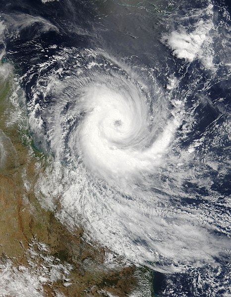
Australia on March 18, 2006, but built strength rapidly. When the Moderate Resolution Imaging Spectroradiometer (MODIS) on the Terra satellite observed the storm at 11:55 a.m. Eastern Australian Daylight Time (00:55 UTC) on March 19, 2006, only a day later, Larry had already reached considerable size and power, with peak sustained winds of 120 kilometers per hour (75 miles per hour). Within the next eighteen hours, according to the Tropical Storm information service at the University of Hawaii, sustained winds reached 185 km/hr (115 mph), just before the storm came ashore. It lost power over land.

This image shows Cyclone Larry as it was bearing down on the coast of Queensland over the Great Barrier Reef. During the next day, Larry caused considerable damage to coastal towns and property, flattening sugar cane fields. According to the Australian Broadcasting Corporation, as much as 90 percent of the Australian banana crop may have been lost in this single storm. Since many trees have been destroyed, it may be many years before the banana industry recovers.

The high-resolution image provided above is provided at the full MODIS spatial resolution (level of detail) of 250 meters per pixel. The MODIS Rapid Response System also provides this image at additional resolutions.
التاريخ
المصدر http://earthobservatory.nasa.gov/NaturalHazards/natural_hazards_v2.php3?img_id=13421
المؤلف NASA image by Jeff Schmaltz, MODIS Rapid Response Team, Goddard Space Flight Center.
الترخيص
(إعادة استخدام هذا الملف)
Public domain يقع هذا العمل في النِّطاق العامّ في الولايات المُتحدة الأمريكيَّة لأَنَّه عملٌ خالِصٌ من إِنتاج وكالة الفضاء الأمريكيَّة. تنصُ حقوق التَّأليف والنَّشر الخاصَّة بوكالة الفضاء الأمريكيَّة على أنَّ "أعمال الوكالة غير مَحميَّة بحقوق التَّأليف والنَّشر ما لم يُذكر خلافُ ذلك". لمزيدٍ من المعلومات انظر القالِب {{PD-USGov}} وصفحة حقوق التَّأليف والنَّشر الخاصَّة بالوكالة وصفحة سياسة الصُّور الخاصَّة بمُختبر الدَّفع النَّفَّاث.
تنبيهات:
إصدارات أخرى Image:Cyclone Larry 2006.jpg

الشروحات

أضف شرحاً من سطر واحد لما يُمثِّله هذا الملف

العناصر المصورة في هذا الملف

يُصوِّر

١٩ مارس 2006

٥٬٩٦٣٬٠٣٧ بايت

٧٬٢٠٠ بكسل

٥٬٦٠٠ بكسل

تاريخ الملف

اضغط على زمن/تاريخ لرؤية الملف كما بدا في هذا الزمن.

زمن/تاريخصورة مصغرةالأبعادمستخدمتعليق
حالي00:29، 19 نوفمبر 2006تصغير للنسخة بتاريخ 00:29، 19 نوفمبر 20065٬600 × 7٬200 (5٫69 ميجابايت)commonswiki>Good kitty== Summary == {{Information |Description=Tropical Cyclone Larry formed off the northeastern coast of Australia on March 18, 2006, but built strength rapidly. When the Moderate Resolution Imaging Spectroradiometer (MODIS) on the Terra satellite observed th

ال1 ملف التالي مكررات لهذا الملف (المزيد من التفاصيل):

ال3 صفحات التالية تستخدم هذا الملف:

بيانات وصفية