ملف:Arabian Desert.jpg

من أرابيكا، الموسوعة الحرة
اذهب إلى التنقل اذهب إلى البحث

Arabian_Desert.jpg(500 × 428 بكسل حجم الملف: 116 كيلوبايت، نوع MIME: image/jpeg)

ملخص

الوصف

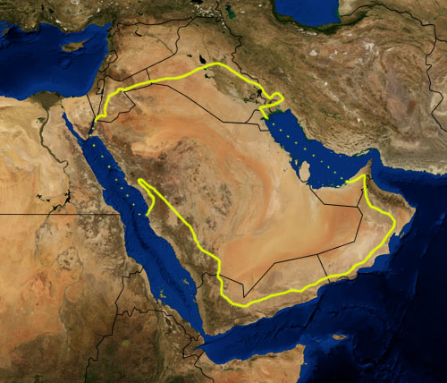
This is a map showing the location of the Arabian Desert. The yellow line encloses ecoregions as delineated by the World Wide Fund for Nature: the "Arabian Desert and East Sahero-Arabian xeric shrublands", and the "Arabian Gulf desert and semi-desert" (a narrow strip along the Persian Gulf coast), and the "Red Sea Nubo-Sindian tropical desert and semi-desert" (along the Red Sea and in patches throughout the Arabian peninsula). National boundaries are shown in black. I, Pfly, made it using NASA Blue Marble imagery and ecoregion GIS data which I simplified and digitized in Photoshop.

WWF code PA1303
التاريخ
المصدر NASA, plus my additions by myself.
المؤلف Pfly

ترخيص

Public domain يقع هذا العمل في النِّطاق العامّ في الولايات المُتحدة الأمريكيَّة لأَنَّه عملٌ خالِصٌ من إِنتاج وكالة الفضاء الأمريكيَّة. تنصُ حقوق التَّأليف والنَّشر الخاصَّة بوكالة الفضاء الأمريكيَّة على أنَّ "أعمال الوكالة غير مَحميَّة بحقوق التَّأليف والنَّشر ما لم يُذكر خلافُ ذلك". لمزيدٍ من المعلومات انظر القالِب {{PD-USGov}} وصفحة حقوق التَّأليف والنَّشر الخاصَّة بالوكالة وصفحة سياسة الصُّور الخاصَّة بمُختبر الدَّفع النَّفَّاث.
تنبيهات:

الشروحات

أضف شرحاً من سطر واحد لما يُمثِّله هذا الملف

العناصر المصورة في هذا الملف

يُصوِّر

٢٢ يناير 2007

١١٨٬٥٧١ بايت

٤٢٨ بكسل

٥٠٠ بكسل

تاريخ الملف

اضغط على زمن/تاريخ لرؤية الملف كما بدا في هذا الزمن.

زمن/تاريخصورة مصغرةالأبعادمستخدمتعليق
حالي01:39، 23 يناير 2007تصغير للنسخة بتاريخ 01:39، 23 يناير 2007500 × 428 (116 كيلوبايت)commonswiki>Pfly{{Information |Description=This is a map showing the location of the Desert. The yellow line encloses ecoregions as delineated by the World Wide Fund for Nature: the "Arabian Desert and East Sahero

ال1 ملف التالي مكررات لهذا الملف (المزيد من التفاصيل):

الصفحة التالية تستخدم هذا الملف:

بيانات وصفية