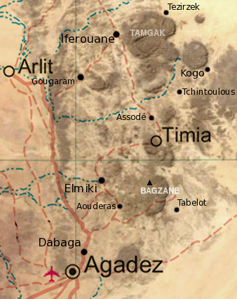
ملف:Air massif sat map south.png

من أرابيكا، الموسوعة الحرة
اذهب إلى التنقل اذهب إلى البحث

Air_massif_sat_map_south.png(338 × 426 بكسل حجم الملف: 235 كيلوبايت، نوع MIME: image/png)

الوصف Map of the southern half of the Air Massif, northern Niger. Created from an overlay of PD File:Un-niger.png and PD File:Niger_BMNG.png, plus map locations derived from fallingrain.com.
التاريخ (UTC)
المصدر
المؤلف


هذا رسمٌ مُعَدَّلٌ رقميَّاً من النسخة الأصليَّة. التعديلات هي: Overlay of two images, scale, add locations, names. يُمكن الاطلاع على النسخة الأصليَّة هنا: Niger BMNG.png.

Public domain أنا، مالِك حقوق تأليف ونشر هذا العمل، أجعله في النِّطاق العامِّ، يسري هذا في أرجاء العالم كلِّه.
في بعض البلدان، قد يكون هذا التَّرخيص غيرَ مُمكنٍ قانونيَّاً، في هذه الحالة:
أمنح الجميع حق استخدام هذا العمل لأي غرض دون أي شرط ما لم يفرض القانون شروطًا إضافية.

سجلُّ الرَّفع الأصيل

This image is a derivative work of the following images:

  • Image:Niger_BMNG.png licensed with PD-WorldWind
    • 2006-04-26T18:55:04Z Hautala 2427x1919 (3901170 Bytes) {{PD-WorldWind}} Satellite image of Niger in September 2004. Screenshot from NASA World Wind, Blue Marble Next-Generation layer. [[Category:Satellite images of countries]]

Uploaded with derivativeFX

الشروحات

أضف شرحاً من سطر واحد لما يُمثِّله هذا الملف

العناصر المصورة في هذا الملف

يُصوِّر

٢٤٠٬٣٦٠ بايت

٤٢٦ بكسل

٣٣٨ بكسل

تاريخ الملف

اضغط على زمن/تاريخ لرؤية الملف كما بدا في هذا الزمن.

زمن/تاريخصورة مصغرةالأبعادمستخدمتعليق
حالي23:31، 17 ديسمبر 2008تصغير للنسخة بتاريخ 23:31، 17 ديسمبر 2008338 × 426 (235 كيلوبايت)commonswiki>T L Miles{{Information |Description= Map of the southern half of the Air Massif, northern Niger. Created from an overlay of PD File:Un-niger.png and PD File:Niger_BMNG.png, plus map locations derived from fallingrain.com. |Source=*Image:Niger_BMNG.png |Date=

ال1 ملف التالي مكررات لهذا الملف (المزيد من التفاصيل):

الصفحة التالية تستخدم هذا الملف: